Surrey Route Guide
Mountain Bike Destination: Peaslake (The Hurtwood)
Nestled away in a valley between two slopes of the Surrey Hills, Peaslake feels a bit like a village from another time. The topography here means that the ever increasing quota for new housing in the south east has failed to impact. There's a real sense of place to the village and you can almost feel the community spirit in the air. The village shop still thrives. And ever since the government pulled the plug on it to cut costs in 1994, the local school has been funded by donations.
However, these social charms are not the principle reason why every weekend mountain bikers descend on the village in their droves. On a warm summer Sunday the benches outside the Hurtwood Inn can be rammed with our species. Even on a dark drizzly afternoon in November, it is not unusual to see a couple of riders sheltered in the village centre's bus stop. Alongside its rural atmosphere, Peaslake's great virtue is its location. To either side, on steep wooded hills rising directly out of the village, is some of the best off-road biking in the whole southeast of England.
"There are just so many great trails and so many bikers who visit," enthuses Howard Wagstaff, who just three months ago had the wisdom to open a bike shop (Pedal & Spoke) in the village. "I'll get 40,000 people come past this shop a year. I couldn't believe it was just sitting here empty and no one had opened up a bike shop before."
So far Howard's staple business has been selling inner tubes, energy bars and the odd accessory. Now, though, he's secured dealership with Santa Cruz bikes. When that gets up and running, the plan is to have six demo rigs that potential buyers can take directly out of the shop to test in the hills. Chatting to Howard about his venture, I can understand his enthusiasm. It really is brilliant how immediate you cross the threshold from being in the village with its handy amenities to being out there in the wild woods, mountain biking properly.
The trails exist in a large area of hilly forest known as the Hurtwood. It's all privately owned, but ever since an agreement was struck as long ago as 1926 the public have been allowed to freely roam on it. Managed on behalf of the owners by a charity called Hurtwood Control, mountain bikers are explicitly welcomed but are asked to abide by a code of conduct. It's all common sense really.
The trails vary in quality and seemingly run everywhere. By and large they comprise wriggly stretches of singletrack but there are also some steep drops and biggish jumps for the more freeride inclined. Many of the best trails have been worked on by officially authorised volunteer groups. Their landscaping has made them both more fun and more sustainable.
There is something very cosy -and again community spirited- about these co-operative arrangements. The only downside is that the trails are not always the easiest to find. Signage is very limited and no formal map has been produced of the actual mountain bike runs.


From his shop Howard sells - for £3.00-laminated maps which mark all the bridleways and firebreaks. He will then happily draw onto it entrances to sections of singletrack suitable to a rider's needs. When I visited he also showed me around in person. Here are my findings.
Finding the trailheads
Trails run absolutely everywhere and you could happily head off into the woods and just see what you come across. Another option would be to hook up with other riders in the village and ask to tag along.
The easiest way to find the trails I've recommended below is to first head to one of the two viewpoints on either side of the valley. Both sit at the top of steep south facing escarpments and actually have nearby car parks. These instructions outline how to quickly reach them riding from the village.


Pitch Hill: Follow the street of Walking Bottom and then turn left through the large car park at the edge of the village. A bridleway runs from the map board at the end of the car park into the woods. Follow this until you reach another car park. Another trail to your left should take you up to the viewpoint.
Holmbury Hill: Follow Radnor Road up out of the village. Turn left off the road where the gradient eases besides a covered reservoir (to the right is the entrance to Barry Knows Better). Now follow the track that parallels the road, keeping as close to straight as possible when the track meets a junction with a multitude of bridleways. At the top is the viewpoint. From here on a clear day, you can see Britain's biggest village at Cranleigh, the Top Gear test track and the South Downs.
Recommended Runs:
Proper Bo: Including a few small jumps and slaloming through the trees, this is a good stretch to kick a ride off on. In the wet it proved slippery on some of the roots but that just helps get the adrenaline going. From the Pitch Hill viewpoint, follow the track that puts the hill on your left and the view on your right. At a junction, veer right to keep following the top of the escarpment. Stick to this simple rule and eventually you'll find an obvious slither of singletrack winding off to your left.
T4: A pleasant flowing run back into Peaslake that gets more intense the lower down the hill you get. To find it: turn right where Proper Bo meets its third track crossing near the valley floor (there is only a tiny section of Proper Bo remaining after this). Fork right at the track crossroads to climb a steep fire road. At the top, just before you reach another crossroads, find the singletrack trail off to the left (not to be confused with the footpath marked by a bollard). Near the bottom, the trail runs alongside the village cemetery fence. Where there's a fork, veer left for a challenging and, if you so choose, steep finale (with slippery-when-wet off-camber entry) down into the main car park on Walking Bottom.
Yoghurt Pots: A bit of a roller coaster this one, swooping in and out of gullies that run down the hillside. Sometimes they're a bit boggy down in the dips, hence the name. (It is also known as Parklife). This is best located by finding the Holmbury Hill lookout then riding the broad track directly away from the escarpment. Entry to the trail is a slither of track off to the right, beyond two older trailheads that have now been closed for archaeological reasons. (The original trail ran over the site of an Iron Age Hill Fort!). When I visited, a rather flimsy looking sign tacked to a tree confirmed the new entrance. Whether it will last the winter or be replaced with sturdier signage remains to be seen.
Telegraph Road: This is a steadier, slightly less technical run that allows you to open up the throttle a bit more. Weaving around ferns and through the odd crater, this trail slaloms along a clearing cut for a telegraph line. For some reason, it reminds me a bit of some backcountry biking I was doing earlier in the year in New Zealand. I really liked backcountry biking in New Zealand. To find this trail: from the end of Yoghurt Pots turn right onto the fire road and continue descending straight over the five way junction. Shortly after you'll pass under the telegraph line. Turn left here. Although it kicks up to start with the trail gradually descents all the way to Holmbury Youth Hostel.
Barry Knows Better: A sweet, flowing run that hugs the pine covered hillside as it drops to Peaslake, this trail is a popular one to finish off on. Easy to find, the start is marked by a large log barricade across the tarmac from the turf covered reservoir halfway along Radnor Road. At the time of first visiting, the trail was known as Barry Knows Best and had a finale that a comprised a big steep eroded mess that saw you skidding and slipping in fits and starts down towards Ewhurst Road. Thankfully trail builders have since completed a vastly improved finish that berms back on itself several times. So smooth, fast and beautiful did I find these hairpin bends on my second visit, I had no option to head straight back up top and have another run.
More Trails
There are plenty more trails to be ridden in the Surrey Hills, both on Pitch and Holmbury Hills and further afield. Nearby Leith Hill is popular option as is Box Hill near Dorking. For a longer endurance ride, it's quite possible to ride off road from Guildford to Dorking with only the interruption of road crossings.
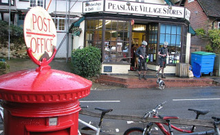
Local Amenities: Pedal and Spoke bike shop, The Hurtwood Inn and the village stores are all clustered around the central junction in Peaslake. The Inn does beer and pub grub; the village stores: tea, cake and savoury snacks; the bike shop: espressos and bike bits. What more could you want?
Getting there: A good destination for London mountain bikers, Peaslake is situated within 15 miles of Junction 9 of the M25. It sits on an unclassified road between the villages of Shere and Ewhurst. A free sizeable car park popular with mountain bikers sits on the street of Walking Bottom just on the edge of the village. The nearest train station is Gomshall, 1.4miles miles away.
Further information